Dominic's Tameside Trail Run - stage information
Dominic's Tameside Trail Run Attempt - 27 October 2004
Start Broadbottom - Lymefield Visitor Centre 08:30
Stage Info
Stage |
To (OS Grid Ref.) |
Parking |
Dist (m) |
Time |
| 0 | Broadbottom - start (SJ 996 936) map | Limited | 0 | 8:30 |
| 1 | Werneth Low (SJ 971 931) map | Limited | 2.3 | 9:05 |
| 2 | Poleacre Lane (SJ 943 929) map | Limited | 2.4 | 9:35 |
| 3 | A6017 Stockport Rd (SJ 922 937) map | Lay by | 2.9 | 10:00 |
| 4 | Mill Lane (Reddish) (SJ 903 940) map | No | 1.5 | 10:20 |
| 5 | Debdale Park (SJ 895 958) map | Yes | 1.6 | 10:40 |
| 6 | A662 Manchester Rd (SJ 894 982) map | No | 3.3 | 11:20 |
| 7 | Daisy Nook (SD 920 005) map | Yes | 3.3 | 12:00 |
| 8 | Hartshead Pike (SD 960 024) map | No | 3.5 | 12:45 |
| 9 | A635 Manchester Rd (SD 983 036) map | No | 2.7 | 13:20 |
| 10 | Carrbrook (SD 989 009) map | Yes | 2.5 | 13:55 |
| 11 | Hollingworth (SK 007 963) map | No | 4.5 | 14:50 |
| 12 | Broadbottom (SJ 996 936) map | Limited | 2.3 | 15:20 |
Times: These times are an estimate and as the day goes on they are likely to be up to an hour wrong (could be early or late) so please bring an umbrella and warm clothing!
Parking: Where it says No there is probably some parking on nearby roads but there are no convenient spaces next to the point. There is no parking near Hartshead Pike.
Maps: The map links after the grid references open new windows displaying the location on a map. The map scale can be adjusted and you can even display an aerial photo of the location using the controls above the map.
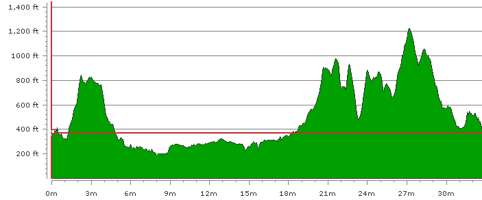
Trail Profile
The profile below shows the hills encountered on the trail. Werneth Low is from 2 to 4 miles, Hartshead Pike is at 21 miles and is followed by Holly Bank and Quick Edge. Noonsun Hill is at 24 miles, Harridge Pike is at 27 miles and then it is mostly downhill to Broadbottom, phew!
Stage Descriptions
Stage 1 - Broadbottom to Werneth Low (2.3 miles)
The route follows the river Etherow for a while and then heads up through woodland before going steeply up onto the Low.
Stage 2 - Werneth Low to Poleacre Lane (2.4 miles)
A short trip through Werneth Low Country Park and then out onto the road along the Low before dropping down through farmland. Muddy track leads out onto A560 Stockport Road which is followed for 200m before turning right onto Poleacre Lane
Stage 3 - Poleacre Lane to A6017 Stockport Road (2.9 miles)
Short trip down the lane and over a field then the route follows the Peak Forest Canal before dropping down to the River Tame at Gibralter Bridge. The trail follows the river through meadows and into the wooded Haughton Dale (parking at end of Meadow Lane). The trail emerges onto the A6017 just north of a lay by.
Stage 4 - A6017 to Mill Lane, Reddish (1.5 miles)
The trail heads north along the road for 100m before truing off to the left down a muddy track. The track leads out into the Tame flood-plain before passing under the M60 (no stopping please) and a railway viaduct before reaching Mill Lane.
Stage 5 - Mill Lane to Debdale Park (1.6 miles)
This stage almost completely urban following minor roads before crossing Reddish Lane and following a path under the A57 Hyde Road to pop up at the west entrance to Debdale Park.
Stage 6 - Debdale Park to A662 Manchester Road / Ashton New Road (3.3 miles)
The trail winds along the north edge of the park before leaving in the north-west and following a rough road between Denton and Fairfield golf courses. Passing Fairfield's club house and Fairfield station the trail crosses the A635 Manchester Road (Ashton Old Road) and heads up past Fairfield High School for Lasses before joining the Ashton Canal. The trail follows the canal for about a mile before joining Buxton Lane which leads up to Manchester Road.
Stage 7 - A662 to Daisy Nook Country Park (3.3 miles)
After briefly following Lewis Road the trail enters Sunny Bank Park (near Droylsden High School) and follows Sunny Bank Brook down to Edge Lane. Turning right onto edge lane the trail soon leaves the road again and heads up towards the Greenside estate. Muddy paths are followed to the north of the estate before dropping down to the Medlock Valley and then on towards Lumb Farm. From the farm the trail follows the disused Hollinwood Branch Canal to Daisy Nook Park.
Stage 8 - Daisy Nook to Hartshead Pike (3.5 miles)
From the car park the trail continues to follow the Hollinwood Branch Canal until it meets the Fairbottom Branch Canal which it then follows to Bardsley Bridge on the A627 Oldham / Ashton Road. The trail passes through a tunnel under the road and emerges onto Waggon Road which is then followed to Alt Hill Road. A short way up Alt Hill Road the trail turns down Mill Brow and then leaves the road just before it crosses the River Medlock. Footpaths are followed to the B6194 Lees Road. From Lees Road muddy footpaths are followed through fields and up to Hartshead Pike.
Stage 9 - Hartshead Pike to A635 Manchester Road (2.7 miles)
From the Pike the trail drops down to the farm to the east and crosses a field and Broadcarr Lane before traversing the ridge north to Holly Bank. From there it drops down to Lees Road and turns north - Lees Road soon becoming Under Lane. From Under Lane the trail follows a footpath over Quick Edge and down to the village of Quick. Passing through Quick the trail crosses the A6050 and A670 where is goes down a garden path and crosses the railway, River Tame and Huddersfield Narrow Canal before emerging on the A635.
Stage 10 - A635 to Carrbrook (2.5 miles)
From the A635 the trail follows a small cul-de-sac and crosses the B6175 Huddersfield Road before heading up a steep unmade track (Shadworth Lane) to Noonsun Farm. From the farm the rough farm track (Moor Edge Road) is followed south to Buckton Castle Quarry. From the quarry entrance the trail cuts across a boggy field and into a wood. A U turn at the end of the wood takes a path back towards Carrbrook emerging onto Castle Lane which is followed south to the end.
Stage 11 - Carrbrook to Hollingworth A628 (4.5 miles)
Just round the corner from Castle Lane the trail heads uphill on a good farm track and then heads up the moor on a footpath. The highest point on the trail is soon reached and then it is downhill to Higher Swineshaw Reservoir where the trail crosses the dam and heads round the side of Lees Hill. From Lees Hill the trail drops down through Hollingworth Nature Reserve and some fields to reach Green Lane which is then followed to the A628.
Stage 12 - Hollingworth to Broadbottom (2.3 miles)
Straight over the A628 from Green Lane a track leads down toward the River Etherow where a small section of park leads onto Water Lane which is then followed to the A57 Woolley Lane near Woolley Bridge. Straight over the A57 there is a farm track than then leads to a footpath through fields. The path leads to a farmyard which is skited to reach Hague Road. Hague Road is followed to Broadbottom where it joins Gorsey Brow which in turn joins Market Street. The last downhill stagger takes the trail back to the start at Lymefield Visitor Centre.